
Korea Rivers, Lakes, Mountains & Hiking Trails
A Complete Guide to Streams, Rail Trails & National Parks
🌿 Korean Rivers and Stream Parks: An Underappreciated National Treasure
updated Things to Do In Yeongjongdo International City
Yeongjongdo the Hamptons of Seoul
Updated Things to Do on Yeongjongdo
Yeongjongdo Redevelopment Proposals
I have been hiking in Korea since 1979, when I first arrived as a Peace Corps Volunteer. Over the decades, I’ve explored most of the major mountain trails and national parks. What continues to surprise me is not just Korea’s mountains—but how the country keeps expanding and improving its world-class network of trails, rivers, and urban green spaces.
Korea has become a global leader in:
Urban stream restoration
Integrated cycling networks
Rail-to-trail conversions
While visitors often imagine Korea as a country of granite peaks and temple hikes, everyday outdoor life—especially in Seoul—happens somewhere else entirely:
👉 along rivers, streams, and linear parks woven into the city.
Suggested Top 10 Must-Do Walks


This ranking is my suggested editorial shortlist for readers — the access details below are based on the sources cited.
Cheonggyecheon (청계천)
One of Seoul’s best-known urban walks. Multiple subway stations are close to the stream, including Gwanghwamun Station, City Hall Station, Euljiro 1-ga Station, and Jongno 3-ga Station.
Naver Map: 청계천 / 광화문역 5번출구 / 종로3가역 15번출구 [redaily.co.kr], [ktxtrain.tistory.com]
Hongjecheon + Hongje Waterfall (홍제천 / 홍제폭포)

A quieter local stream walk with a notable waterfall. One source says Hongje Station (홍제역)
Exit 2 is about a 10-minute walk to the waterfall area.
Naver Map: 홍제폭포 / 홍제천 / 홍제역 2번출구 [maps.google.com]
Gyeongui Line Forest Park (경의선숲길)
A former railway turned into a 6.3 km linear urban park. The park is accessible from Hongik Univ. Station, Gongdeok Station, Daeheung Station, and Hyochang Park Station.
Naver Map: 경의선숲길 / 홍대입구역 3번출구 / 효창공원앞역 [seoulmetro.co.kr], [gil.seoul.go.kr]
Gyeongchun Line Forest Trail (경춘선숲길)
A quieter rail-trail in Nowon-gu. The park runs from the area around Kwangwoon Univ. Station through Gongneung-dong and Hwarangdae Station.
Naver Map: 경춘선숲길 / 광운대역 / 화랑대철도공원 [namu.wiki]
Tancheon (탄천)
A long, flat ecological stream walk with several official access points: Munjeong, Garak Market, and Sports Complex.
Naver Map: 탄천 산책로 / 송파둘레길 탄천구간 [songpa.go.kr]
Gimpo Laveniche / Golden Waterway (라베니체 / 금빛수로)
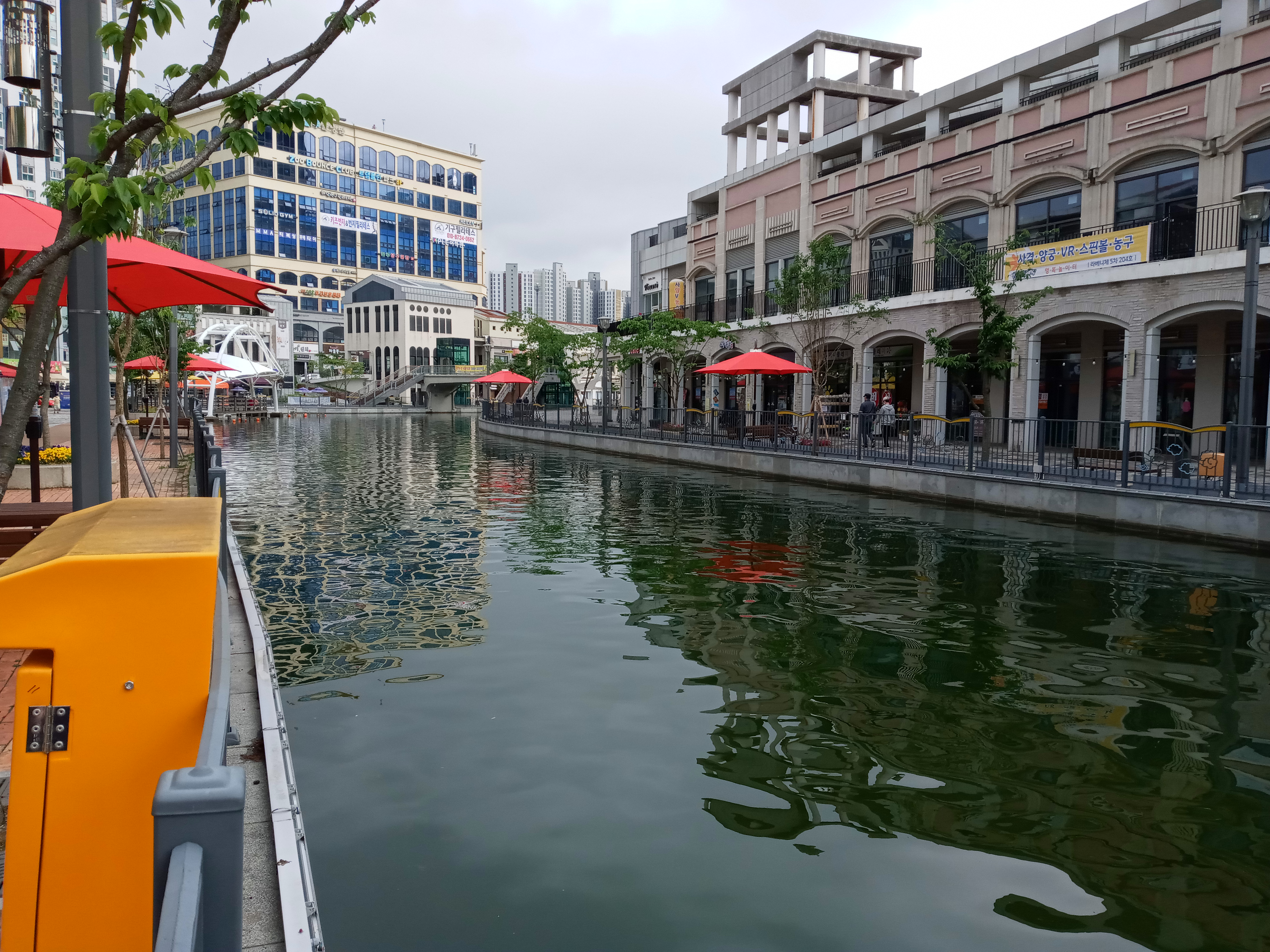
Gimpo’s canal-style water walk. Official transit guidance says Janggi Station Exit 5 and walk 500 m. the five-mile long canal (8 km) is lined with restaurants and is a very colorful place to walk.
Naver Map: 라베니체 마치에비뉴 / 금빛수로 / 장기역 5번출구 [gimpo.go.kr]
Songdo Central Park (송도 센트럴파크)
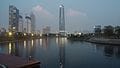
The nearest subway station is Central Park Station on Incheon Line 1, and the park is described as a short walk from the station.
Naver Map: 송도 센트럴파크 / 센트럴파크역 [koreatravelpost.com], [roamscapes.com]
Cheongna Lake Park (청라호수공원)
A large lake park in Incheon. One travel source says to take the AREX to Cheongna International City Station, then Bus 46 to the park; another says Bus 701 or 702 from the same station.
Naver Map: 청라호수공원 / 청라국제도시역 [inmykorea.com], [tripxl.com]
Ilsan Lake Park (일산호수공원)
A classic easy urban lake walk. Jeongbalsan Station is within walking distance, and one source says the park is about a 12-minute walk from the station.
Naver Map: 일산호수공원 / 정발산역 [in.pinterest.com]
Seokchon Lake (석촌호수)
Best reached via Jamsil Station for Lotte World / tower access or Seokchon Station for easier access to the lake itself.
Naver Map: 석촌호수 / 잠실역 / 석촌역 [alltrails.com], [english.seoul.go.kr]
🌉 The Urban Water Network (Seoul & Capital Region)
At the center is the Han River (한강)—the backbone of Seoul’s outdoor culture.
From it extend restored tributaries:
Cheonggyecheon (청계천)
Anyangcheon (안양천)
Jungnangcheon (중랑천)
Tancheon (탄천)
Yangjaecheon (양재천)
👉 Together, they form a continuous network of walking and cycling routes across the region.
💡 Canals, Regional Systems & Historic Waterways
Gyeongin Ara Waterway (경인 아라뱃길)
Links the Han River (한강) to the Yellow Sea – very windy trail at times.
Anchor route of the Four Rivers Bike Trail
Gimpo Laveniche Canal (라베니체)
Café-lined urban canal (“Venice of Korea”)
Suwoncheon (수원천)
Flows through Hwaseong Fortress (수원 화성) (UNESCO)
🌿 Hidden Urban Stream Gem
✔ Hongjecheon Stream (홍제천) — Waterfall + Quiet Trail
Flows from Bukhansan foothills into Seodaemun-gu
Quiet, local walking environment
🌊 Highlight: Hongje Waterfall (홍제폭포)
~20 m tall illuminated waterfall
Located between Inwangsan (인왕산) and Bukaksan (북악산)
🚇 Access
Hongje Station (홍제역, Line 3)
→ Exit 2 → 10 min walk
👉 Combine with hikes on:
Inwangsan (인왕산)
Ansan (안산)
Tancheon
The Songpa-gu official Tancheon section page describes the Tancheon walking course as a 7.4 km ecological route running from the Jangjicheon confluence through Garak Market and Jamsil Sports Complex to the Han River. It explicitly lists nearby subway access points, including Jangji Station Exit 4 (900 m / 15 min), Munjeong Station Exit 3 (700 m / 10 min), Garak Market Station Exit 8 (700 m / 10 min), and Sports Complex Station Exit 4 (1.4 km / 25 min). [songpa.go.kr]
The Visit Gangnam page also says Yangjaecheon & Tancheon Embankment Path can be reached from Maebong Station or Dogok Station, and that the Yangjaecheon path connects into Tancheon, which then flows about 2 km more to the Han River. [visitgangnam.net]
💡 Canals, Regional Systems & Historic Waterways
Gyeongin Ara Waterway (경인 아라뱃길)
Links the Han River (한강) to the Yellow Sea
Anchor route of the Four Rivers Bike Trail
✅ Gimpo Laveniche Canal (라베니체 운하 / 김포 라베니체)
Short, walkable urban canal in Gimpo
Nicknamed “Venice of Korea”
Designed for:
cafés
night strolling
waterfront dining
👉 Best at night — strong lighting + reflections
👉 Easy add-on from western Seoul / Incheon outings
Suwoncheon (수원천)
Flows through Hwaseong Fortress (수원 화성) (UNESCO) in Suwon City Passes beneath historic flood-control gates
🌉 The Urban Water Network (Seoul & Capital Region)
From the Han River extend restored tributaries:
Cheonggyecheon (청계천)
Anyangcheon (안양천)
Jungnangcheon (중랑천)
✅ Tancheon (탄천)
Yangjaecheon (양재천)
👉 These streams form one of the most continuous urban walking and cycling systems in the world.
🚆 Rail-to-Trail Urban Walks
✔ Gyeongui Line Forest Park (경의선 숲길)
“Seoul’s Rail Park”
6.3 km green corridor (former railway)
Route: Hongdae → Gongdeok → Yongsan
🚇 Access
Hongik Univ. Station (홍대입구역)
Gongdeok Station (공덕역)
Daeheung Station (대흥역)
Hyochang Park Station (효창공원앞역)
✔ Gyeongchun Line Forest Trail (경춘선 숲길)
~5.4 km rail-trail in Nowon-gu (노원구)
Preserved tracks + quiet local environment
🚇 Access
Kwangwoon Univ. Station (광운대역)
Wolgye Station (월계역)
🌊 Han River Park System (한강공원)
Yeouido Hangang Park (여의도 한강공원)
Ttukseom Hangang Park (뚝섬 한강공원)
Mangwon Hangang Park (망원 한강공원)
Jamsil Hangang Park (잠실 한강공원)
👉 Includes bike paths, picnic areas, and campgrounds
⛰️ Major Mountains (Seoul & Nearby)
Bukhansan National Park (북한산국립공원)
Dobongsan (도봉산)
Gwanaksan (관악산)
Cheonggyesan (청계산)
Suraksan (수락산) / Bulamsan (불암산)
👉 Connected by Seoul Dulle-gil (서울둘레길) and Seoul City Wall Trail (서울성곽길)
Han River (한강)
Nakdong River (낙동강)
Geum River (금강)
Yeongsan River (영산강)
Seomjin River (섬진강)
Taehwa River (태화강)
🏞️ Central Region
Lakes & Reservoirs
Soyang Lake (소양호)
Uiam Lake (의암호)
Chungju Lake (충주호)
Gyeongpo Lake (경포호)
National Parks
National Parks in Korea (with nearest cities)
South Korea has over 20 national parks, mostly mountainous, with a few coastal and one historic park. [en.wikipedia.org], [ko.wikipedia.org]
🟩 Seoul / Capital Region
- Bukhansan (북한산) — Seoul
- Chiaksan (치악산) — Wonju [ko.wikipedia.org]
👉 These are among the easiest to integrate into a Seoul-based itinerary.
🟦 Northeast (Gangwon / East Coast)
- Seoraksan (설악산) — Sokcho [topasiatour.com]
- Odaesan (오대산) — Gangneung / Pyeongchang [ko.wikipedia.org]
- Taebaeksan (태백산) — Taebaek / Yeongwol [ko.wikipedia.org]
👉 This is Korea’s most dramatic alpine region—what many people imagine when they think of “Korean national parks.”
🟨 Central Korea
- Songnisan (속리산) — Boeun / Sangju [ko.wikipedia.org]
- Gyeryongsan (계룡산) — Daejeon / Gongju [ko.wikipedia.org]
- Woraksan (월악산) — Jecheon / Chungju [ko.wikipedia.org]
- Sobaeksan (소백산) — Danyang / Yeongju [ko.wikipedia.org]
👉 These parks sit in the interior spine of the peninsula—less famous internationally, but deeply tied to traditional pilgrimage and mountain culture.
🟥 Southeast (Gyeongsang Region)
- Juwangsan (주왕산) — Cheongsong / Yeongdeok [ko.wikipedia.org]
- Gayasan (가야산) — Hapcheon / Seongju [ko.wikipedia.org]
- Gyeongju National Park (경주) — Gyeongju (historic city itself) [listnationalpark.us]
- Palgongsan (팔공산) — Daegu [ko.wikipedia.org]
👉 A mix of mountains + cultural heritage, including temples and Silla-era sites.
🟪 Southwest (Jeolla Region)
- Naejangsan (내장산) — Jeongeup / Suncheon [ko.wikipedia.org]
- Mudeungsan (무등산) — Gwangju [ko.wikipedia.org]
- Wolchulsan (월출산) — Yeongam / Gangjin [ko.wikipedia.org]
- Byeonsan-bando (변산반도) — Buan [detailedpedia.com]
👉 Known especially for autumn foliage and softer, rolling terrain compared to the east.
🟫 South / Multi‑province mountain zones
- Jirisan (지리산) — Namwon / Gurye / Hadong [ko.wikipedia.org]
- Deogyusan (덕유산) — Muju / Geochang [detailedpedia.com]
👉 These are large, multi-day hiking landscapes—especially Jirisan, the first national park (1967). [National P…cted Areas]
Tiger Reintroduction plan for Jirisan – what is the status?
Jirisan was once tiger country—the great Amur tiger roamed these ridges until the early 20th century. Today, no wild tigers remain in South Korea, and while there have been discussions about reintroducing them, such plans are still theoretical. Instead, Jirisan has become a testing ground for restoration: the successful reintroduction of Asiatic black bears, now numbering over 80, suggests that one day, perhaps, larger predators could return—but for now, the tiger survives here only in myth, memory, and imagination.
🌊 Coastal & Marine Parks
- Taeanhaean (태안해안) — Taean / west coast towns [ko.wikipedia.org]
- Hallyeohaesang (한려해상) — Tongyeong / Geoje / Yeosu [ko.wikipedia.org]
- Dadohaehaesang (다도해해상) — Mokpo / Wando / islands [detailedpedia.com]
👉 These are mostly island and coastal ecosystems, very different from the mountain parks—and often overlooked.
🏝️ Jeju Island
- Hallasan (한라산) — Jeju City / Seogwipo [listnationalpark.us]
👉 Korea’s highest mountain sits in the center of the island—completely different volcanic landscape.
🏯 Fortress Landscapes & Historic Trails
Namhansanseong Fortress (남한산성) one of my favorite places to hike
Hwaseong Fortress (수원 화성)
Achasan Fortress (아차산성)
Mongchontoseong (몽촌토성)
🌄 Southern Korea Highlights
Jirisan National Park (지리산국립공원)
Hallasan National Park (한라산국립공원)
Busan region:
Geumjeongsan (금정산)
Jangsan (장산)
Igidae Coastal Trail (이기대 해안길)
🌴 Jeju Island System
Jeju Olle Trail (제주올레길)
Jeju Dulle-gil (제주둘레길)
🚴 National Trail Networks
Hiking
Baekdudaegan Trail (백두대간)
East Coast Trail (동해안트레일)
Seoul Dulle-gil (서울둘레길)
Cycling
Four Rivers Bike Path (4대강 자전거길)
one can bike from Seoul to Busan and beyond. there are organized bike treks available
🌊 Incheon Coastal & Island System
🌆 Incheon City Highlights (Gateway to the Islands)
Before heading out to Yeongjongdo or Ganghwado, it’s worth spending some time in Incheon proper, which offers a compact mix of history, ports, parks, and hills overlooking the West Sea.
📍 Key Sites
- Jayu Park (자유공원)
- Korea’s first modern Western-style park, opened in the late 19th century. Located above the old port, it offers elevated views over Incheon Harbor and
- is one of the best places to understand the city’s role as Korea’s historic international gateway.
👉 The park is also home to the statue of General MacArthur, reflecting its later significance during the Korean War.
- Chinatown (차이나타운)
- Located just below Jayu Park, this is Korea’s only official Chinatown, dating back to the opening of Incheon port in 1883.
- Today it’s a lively mix of:
-
- historic buildings and gates
- street food and bakeries
- and the birthplace of Korea’s famous jajangmyeon (black bean noodles)
- . One of the highlights of Incheon’s Chinatown is the Jajangmyeon museum, which, for some reason, does not have an attached Jajangmyeon restaurant!
- Chinatown itself at one time was run down and fading away, but it was rediscovered about 20 years ago and turned into a tourist destination, and has once again become a real “Chinatown” with decent Chinese restaurants.
The area blends Qing-era influences with Korean adaptation, giving it a slightly cinematic feel.
- Wolmido Island (월미도)
- A small island (now connected by road) historically used as a military outpost, but today transformed into a casual seaside entertainment area.
Highlights include:
-
- a waterfront boardwalk
- small amusement rides and nostalgic attractions
- open views across the harbor
- Wolmido played a key role in the Korean War. In September 1950, Wolmido was the opening target of General Douglas MacArthur’s Incheon Landing (Operation Chromite)—a daring amphibious assault that ultimately turned the tide of the war. [britannica.com]
The island itself was critical. Positioned at the entrance to Incheon Harbor and connected by a narrow causeway, it functioned as a natural defensive stronghold. U.N. forces had to seize Wolmido first before any larger landing could proceed, and by midday on September 15, it had been taken and converted into a forward command position. [history.navy.mil]
What made the operation so risky—and ultimately so remarkable—was the environment.
The Incheon coastline has some of the most extreme tidal ranges in the world, exceeding 30 feet, exposing vast mudflats at low tide. [history.navy.mil], [encyclopedia.com]
-
- At low tide, ships could not approach—the harbor became a wide expanse of mud
- Landing troops had to adhere to extremely narrow timing windows tied to high tide
- In practice, the first wave landed on Wolmido in the morning, and then forces were forced to wait hours for the tide to return before launching the main assault onto Incheon itself [history.navy.mil], [unc.mil]
These same conditions that made the landing so dangerous also made it unexpected. The North Korean forces believed such a landing was nearly impossible, which allowed MacArthur to achieve a decisive element of surprise, allowing the UN forces to split the North Korean forces and led to the recapture of Seoul, and was a key turning point in the War.
Today, Wolmido feels casual and almost nostalgic—but it is, quite literally, the place where geography and timing combined to reshape the course of the Korean War.
- Gyeyangsan (계양산) / “Kyeasan” Mountain
- The main mountain of northern Incheon, rising above the city and offering one of the best urban-to-coastal panorama hikes in the region.
-
- Moderate hiking routes
- Views stretching toward the Han River basin and out to the Yellow Sea
- Popular with locals but still quieter than Seoul’s main peaks
👉 It’s a good counterpart to Ganghwa’s Manisan—less historic, but more urban and accessible.
✍️ Background Context
Incheon has long functioned as Korea’s gateway to the outside world, formally opening to foreign trade in 1883. This explains its unusual mix of:
- Chinese influences (Chinatown)
- Western-style parks (Jayu Park)
- and port infrastructure layered across centuries
Unlike Seoul, which developed inland, Incheon’s identity is tied to water, trade, and arrival—a theme that continues as you move outward to Yeongjongdo and Ganghwa.
✅Best quick stop: Chinatown + Jayu Park combo
- Best casual seaside vibe: Wolmido
Pro-Tip the best sashimi places are located a few blocks away from the coastal road, those on the road are overpriced in my experience.
- Best city hike: Gyeyangsan
- Best historical context: Incheon port area
Incheon Urban & Coastal Parks
Songdo Central Park (송도 센트럴파크)
Incheon Grand Park (인천대공원)
Sorae Ecology Park (소래습지생태공원)
Cheongna Lake Park (청라호수공원)
🌉 Ara Canal Corridor
Gyeongin Ara Waterway (경인 아라뱃길)
Ara Falls (아라폭포)
Ara Maru Observatory (아라마루 전망대)
West of Seoul: Yeongjong Island (영종도) & Ganghwa Island (강화도)
A nature, history, and coastal escape guide
These two islands off the west coast of Incheon offer very different but complementary experiences.
Yeongjongdo is an evolving seaside city anchored by the international airport, blending beaches and preserved forests.
Ganghwado, further north, feels older and more elemental—defined by mountain trails, ancient temples, and layered history.
Together, they make for one of the most interesting multi-day escapes from Seoul.
🌊 Yeongjong Island (영종도)
📍 Highlights
Eurwangni Beach (을왕리해수욕장)
The closest beach to Seoul, with a slightly retro 1970s seaside vibe. Despite its dated feel, it has some excellent sashimi and seafood restaurants along the shore.
Wangsan Beach (왕산해수욕장)
Just next door, this beach is quieter and less developed—better suited for a more relaxed coastal walk.
Yeongjong Seaside Park (영종 씨사이드파크)
A long coastal park with cycling and walking paths stretching across reclaimed shoreline.
World Peace Forest (세계평화의숲)
One of Yeongjongdo’s true hidden gems.
I lived near the trailhead for several years after I retired and would take long, wandering daily walks through the forest. Wildlife sightings were common—water deer, wild boar, badgers, foxes, ducks, and feral cats (which explains the lack of squirrels).
The main trail runs for about five miles along a gently winding forest path lined with cherry and pine trees, eventually reaching a lotus pond and a small hill. From there, the trail network continues toward Baekdusan Peak (백두산)—the highest point on the island—which in turn connects to Yonggungsa Temple (용궁사).
Yonggungsa Temple (용궁사)
History
Yonggungsa Temple on Yeongjong Island is considered a “thousand-year temple” (천년고찰) with origins traditionally traced back to the Unified Silla period. Founding (Silla period) The temple is traditionally said to have been founded in 670 CE (10th year of King Munmu of Silla) by the famous monk Wonhyo (원효대사). At that time, it was called Baegunsa (백운사), named after its setting on the slopes of Baekdusan Peak (백두산)
✍️ Background
Yeongjongdo was transformed into the site of Incheon International Airport (인천국제공항) through a massive land reclamation project that merged several smaller islands.
After a rare environmental protest, the government agreed to: preserve large portions of the island as protected green space, and
develop the AREX rail line as both an airport link and suburban commuter route. Today, the area is marketed as Yeongjong International City (영종국제도시). Development continues, but significant forest areas remain intact.
The island also hosts two foreigner-only casinos, which have seen mixed success, as many international visitors stay in Seoul rather than on the island.
🏝️ Ganghwa Island (강화도)
Ganghwado offers one of the best combinations of nature, history, and spirituality near Seoul. It’s an ideal destination if you’re looking for hiking, temple visits, and a slower pace.
🛕 Major Buddhist Temples
Jeondeungsa Temple (전등사) (Temple Stay available)
The most important temple on Ganghwado, founded in 381 CE and often described as one of the oldest surviving temples in Korea.
Located within Samnang Fortress, combining forest paths and fortress walls with traditional architecture.
👉 The only major temple stay program on the island is here, allowing visitors to experience monastic life and meditation. [en.wikipedia.org] [youtube.com]
Bomunsa Temple (보문사) (Seokmodo Island)
A dramatic seaside temple and one of Korea’s important Gwaneum (Avalokitesvara) sacred sites, perched above the West Sea.
Known for cliffside carvings, cave shrines, and striking sunset views. [bing.com]
Jeongsubsa Temple (정수사)
A quiet mountain temple with a notable historic main hall dating to the Joseon period. [m.blog.naver.com]
Jeokseoksa Temple (적석사)
A scenic and less-visited hillside temple, especially attractive in late afternoon light. [m.blog.naver.com]
🥾 Trail System & Hiking
Ganghwado’s trail network is one of its biggest strengths—linking temples, ridgelines, and historical sites.
Key Hiking Areas
Manisan Mountain (마니산)
The island’s best-known hike, leading to the Chamseongdan Altar, traditionally linked to the legendary founder Dangun.
Offers wide west coast views and a moderately challenging climb.
Jeondeungsa & Samnang Fortress Trails
Easy-to-moderate forest walks along fortress walls surrounding the temple—ideal for combining culture and nature.
Jeongsubsa Trail Connections
Quieter routes that link into the Mani Mountain system, with fewer crowds.
Seokmodo Coastal Trails
Shorter hikes near Bomunsa combining cliffs, forest, and sea views—especially good at sunset.
Ganghwa Dolmen Sites (강화 고인돌)
Gwangseongbo (광성보)
Deokjinjin (덕진진)
Chojijin (초지진)
👉 Overall, the trails are informal but highly accessible, and naturally connect many of the island’s key sites.
🗺️ Suggested Itineraries
✅ Classic Day Trip (Best Overall)
Morning – Jeondeungsa Temple
Explore temple grounds and fortress walls
Short forest walk
Late Morning – Mani Mountain or Jeongsubsa
Light hike or temple visit
Lunch – Local specialties
Try ganjang gejang (soy-marinated crab) or countryside Korean set meals
Afternoon – Seokmodo Island
Cross the bridge
Visit Bomunsa Temple
Sunset – Bomunsa cliffs
One of the best sunset views on the west coast
✅ Slow Travel / Overnight Option
Stay overnight at Jeondeungsa Temple Stay
Spend the afternoon walking forest and fortress trails
Participate in evening meditation and morning chanting
✍️ Historical Context
Ganghwado has long served as a strategic refuge island, used by Korean dynasties during foreign invasions. This history explains its unusual concentration of fortresses, temples, and sacred sites.
Sites like Jeondeungsa reflect this dual identity—simultaneously places of spiritual retreat and defensive strongholds.
✅ Final Takeaways
Best quick escape from Seoul: Yeongjong beaches + forest walks
Best cultural/nature experience: Ganghwa temples + trails
Best temple stay: Jeondeungsa
Best hike: Manisan
Best sunset: Bomunsa
👉 Together, these islands offer a rare balance of coastal scenery, history, and quiet green space—all within day-trip distance of Seoul.
Getting Around: Transport Between Incheon, Yeongjong & Ganghwa
The three parts of this guide are well connected, but the experience shifts depending on where you’re going—Yeongjong is easy and integrated, while Ganghwa takes a bit more effort and planning.
🚆 Incheon → Yeongjong Island (영종도)
✅ Easiest Option: AREX Airport Railroad
- Take the AREX All-Stop Train
- Key stops on Yeongjong:
- Unseo (운서역) → main town / restaurants / base
- Yeongjong Station (영종역) → closer to eastern trails
👉 The AREX line directly connects Incheon airport, Yeongjong Island, and Seoul, stopping at multiple local stations along the way. [theseoulguide.com]
- Trains run frequently (every few minutes on the all-stop service) [seoul-airport.com]
- Travel within Yeongjong area: 10–25 minutes depending on stop
👉 Once you arrive, you’ll need a local bus or short taxi ride to reach beaches, Yonggungsa, or forest trailheads.
✅ Bus Option (From Incheon City)
- Direct city buses connect Incheon to Yeongjong:
- Routes like 117, 304, 320 serve Yeongjong districts [incheon.go.kr]
👉 Slower than train, but useful if you’re already near:
- Incheon Terminal
- Chinatown / Jayu Park area
✅ Driving / Taxi
- Crossing via:
- Yeongjong Bridge (영종대교)
- Incheon Bridge (인천대교)
👉 ~20–30 minutes from central Incheon (traffic dependent)
🚐 Yeongjong → Ganghwa (강화도)
There’s no single direct rail route—this leg is where travel becomes more “off the grid”.
✅ Best Overall: Bus (Recommended)
- From Incheon or nearby metro areas → take a bus to Ganghwa Bus Terminal
Typical options:
- City / seated buses (Incheon region)
-
- Routes like 800 or 801 connect to Ganghwa [incheon.go.kr]
- Travel time:
-
- About 1 hour (from Incheon region) [korea360.r…damemo.com]
👉 Once at Ganghwa Terminal: Local buses or taxis take you to temples (Jeondeungsa, Bomunsa, etc.)
✅ Alternative Route (Train + Taxi)
- Subway to outer Incheon (e.g., Geomdan Oryu Station)
- Taxi or bus onward to Ganghwa
👉 This is a workable fallback but less straightforward
(typically involves transfers and short taxi ride) [rome2rio.com]
✅ Driving (Easiest if you can)
- Direct access via:
-
- Ganghwa Bridge (강화대교) or Choji Bridge (초지대교)
- Travel time:
-
- ~40–60 minutes from Incheon [korea360.r…damemo.com]
👉 This is the best option if you want to explore multiple sites (temples + trails) in one day.
🚍 Seoul Option (Helpful for context)
Even if you’re not starting in Seoul, many routes pass through it:
- Bus #3000 connects Seoul (Sinchon / Line 2) to Ganghwa
- Runs frequently and takes ~60–90 minutes [korea360.r…damemo.com]
✅ Practical Tips
- Get a T-money card → works on trains, buses, and taxis across all areas [thingstodo…ncheon.com]
- Use Naver Map / Kakao Map → much more accurate than Google Maps in Korea
- Taxis are reliable → useful for last-mile access on both islands
- Ganghwa requires planning → fewer transfers, more spread-out sites
✅ Quick Summary
- Incheon → Yeongjong:
→ Easy (AREX train + short bus/taxi) - Incheon → Ganghwa:
→ Moderate (bus or car; no direct train) - Best overall flow:
→ Train → bus → occasional taxi
⛰️ Manisan Mountain (마니산)
Summit: Chamseongdan Altar (참성단)
Legendary origin site tied to Dangun
Historical Side Note: Exile, Refuge, and Fallen Kings
Ganghwado’s quiet, rural feel today masks a long history as both a royal refuge and a place of exile.
During the 13th-century Mongol invasions, the Goryeo court moved its capital here in 1232, relying on the island’s natural moat-like geography to resist Mongol cavalry forces for decades.
This period cemented Ganghwa’s identity as a defensive sanctuary—remote, fortified, and difficult to attack. [ganghwa.go.kr], [history-maps.com]
That same isolation later made it a natural destination for political exile:
Yeonsangun (연산군) — widely regarded as the most despised tyrant in Joseon history — was deposed in 1506 and exiled to Ganghwa, where he died. [en.wikipedia.org]
Gwanghaegun (광해군) — a capable but politically controversial king — was also exiled to Ganghwa after his overthrow in 1623 before being moved elsewhere. [grokipedia.com]
In a reversal of fortune, the future king Cheoljong (철종) spent years living in poverty on Ganghwa as a political exile before unexpectedly being elevated to the throne in the 19th century. [historical…arallax.kr]
👉 This dual role—as both refuge and prison—gives Ganghwado a distinctive historical atmosphere.
Many of the island’s temples, fortifications, and trails are tied not just to spiritual life, but to moments of political collapse, survival, and forced retreat.
🏝️ Incheon Island Network
Muui-do (무의도)
Deokjeokdo (덕적도)
Ijakdo (이작도)
Seungbongdo (승봉도)
Baengnyeongdo (백령도)
Yeonpyeongdo (연평도)
🔥 Final Takeaway
Korea’s outdoor environment is not just mountains.
It’s a fully integrated system of:
rivers
streams
rail trails
coastal paths
historic landscapes
👉 And the key difference:
You don’t need to plan a big trip to access nature.
It’s already built into daily life.
Standard Disclaimer
These writings and musings are entirely my own and the product of my overactive imagination and is based on my 70 years of lived experience, including 27 years of service in the US State Department as a foreign service Officer (diplomat) working in ten countries and DC, as well as travel to all 50 States, DC, and PR, and travel to 45 countries, and living in Alexandria, VA. Bangkok, Berkeley, DC, Bridgetown, Barbados, Mumbai (Bombay), Medford, Oregon, Seattle, Yakima, Washington and Stocton. California. Along the way, I married the lady of my dreams, learned to speak Korean, Spanish, and Thai. I retired in 2016 and have been splitting my time between Korea, Oregon, and DC, and am moving back to Alexandria this summer.
My writing tends to be neo-beatnik or outlaw poetry style, or wild SciFi speculations or political rants. Some people will be offended by some of my writing, but rest assured that is never my intention.
I have been using AI tools (Chat GP3, Claude, Co-pilot,and Geminia, for research,and editing for grammar, punctuation, and spelling, the words are all mine.
the end
Thanks so much for visiting my site. Your comments are welcome but please play nice…. Reply